Ryton night lights from space
Night Light of Ryton (England) from space (United Kingdom) Src. Average luminocity for 10x10km area is 5.7024% and for 50x50km: 20.4727%.
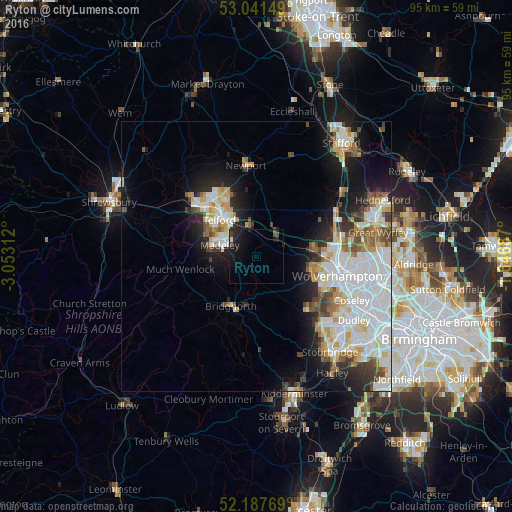
Analysis of Ryton night lights 2016
Square area 10x10 km:
 0.66%
0.66%90-99
0.4%80-89
0.4%70-79
0%60-69
0%50-59
0.4%40-49
1.59%30-39
0.53%20-29
2.65%10-19
10.58%0-9
82.8%Square area 50x50 km:
6.01%90-99
5.4%80-89
1.79%70-79
1.9%60-69
1.86%50-59
1.83%40-49
2%30-39
1.83%20-29
3.31%10-19
7.97%0-9
66.11%Clear (daylight) street map image can be seen on geolist.org.
Map coordinates:
53° 2' 29.4" North, 3° 3' 11.2" West
52° 37' 0" North, 2° 21' 0" West
52° 11' 15.7" North, 1° 38' 48.7" West
Some cities around Ryton sort by population:
• Telford
9.4 km =5.8 mi,  314°
314°
• Hadley
12.9 km =8 mi,  315°
315°
• Wombourn
14.6 km =9.1 mi,  129°
129°
• Bridgnorth
10.1 km =6.3 mi,  208°
208°
• Codsall
10.1 km =6.3 mi,  81°
81°
• Oakengates
11 km =6.8 mi, 322°
• Shifnal
6.2 km =3.9 mi,  345°
345°
• Broseley
9 km =5.6 mi,  267°
267°
2638894 (p: 16,093)
Sources (retrieved 2019-11-25):
» Earth at Night: Flat Maps 2012, 2016