Penkridge night lights from space
Night Light of Penkridge (England) from space (United Kingdom) Src. Average luminocity for 10x10km area is 16.0543% and for 50x50km: 25.7298%.
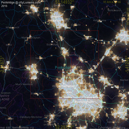
Analysis of Penkridge night lights 2016
Square area 10x10 km:
 1.01%
1.01%90-99
1.01%80-89
0%70-79
1.01%60-69
1.14%50-59
2.65%40-49
3.16%30-39
2.65%20-29
8.33%10-19
36.62%0-9
42.42%Square area 50x50 km:
7.32%90-99
5.99%80-89
2.42%70-79
2.76%60-69
2.77%50-59
2.34%40-49
2.68%30-39
1.95%20-29
4.15%10-19
11.97%0-9
55.65%Clear (daylight) street map image can be seen on geolist.org.
Map coordinates:
53° 8' 57.6" North, 2° 49' 7.4" West
52° 43' 32" North, 2° 6' 56.2" West
52° 17' 51.5" North, 1° 24' 44.9" West
Some cities around Penkridge sort by population:
• Cannock
6.9 km =4.3 mi,  124°
124°
• Stafford
8.9 km =5.5 mi,  359°
359°
• Burntwood
13.6 km =8.5 mi,  111°
111°
• Rugeley
12.6 km =7.8 mi,  72°
72°
• Great Wyrley
9.9 km =6.2 mi,  134°
134°
• Featherstone
9.1 km =5.7 mi,  170°
170°
• Codsall
12.1 km =7.5 mi,  208°
208°
• Norton Canes
11.9 km =7.4 mi, 120°
2640460 (p: 7,791)
Sources (retrieved 2019-11-25):
» Earth at Night: Flat Maps 2012, 2016