Shifnal night lights from space
Night Light of Shifnal (England) from space (United Kingdom) Src. Average luminocity for 10x10km area is 25.5926% and for 50x50km: 17.92%.
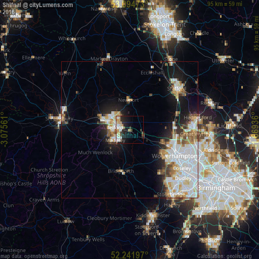
Analysis of Shifnal night lights 2016
Square area 10x10 km:
 5.29%
5.29%90-99
6.08%80-89
3.84%70-79
3.97%60-69
1.72%50-59
1.06%40-49
1.85%30-39
1.72%20-29
8.86%10-19
14.81%0-9
50.79%Square area 50x50 km:
5.2%90-99
4.56%80-89
1.62%70-79
1.76%60-69
1.72%50-59
1.71%40-49
1.65%30-39
1.35%20-29
2.63%10-19
7.73%0-9
70.08%Clear (daylight) street map image can be seen on geolist.org.
Map coordinates:
53° 5' 41" North, 3° 4' 32.2" West
52° 40' 13.5" North, 2° 22' 20.9" West
52° 14' 31.1" North, 1° 40' 9.7" West
Some cities around Shifnal sort by population:
• Telford
5.2 km =3.2 mi,  277°
277°
• Wellington
10.3 km =6.4 mi,  288°
288°
• Ryton
6.2 km =3.9 mi,  165°
165°
• Hadley
8.2 km =5.1 mi, 293°
• Newport
10.7 km =6.6 mi,  358°
358°
• Codsall
12.4 km =7.7 mi,  111°
111°
• Oakengates
5.9 km =3.7 mi,  297°
297°
• Broseley
9.8 km =6.1 mi,  229°
229°
2637985 (p: 6,240)
Sources (retrieved 2019-11-25):
» Earth at Night: Flat Maps 2012, 2016