Wombourn night lights from space
Night Light of Wombourn (England) from space (United Kingdom) Src. Average luminocity for 10x10km area is 45.496% and for 50x50km: 34.6773%.
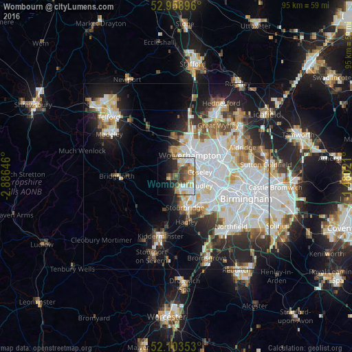
Analysis of Wombourn night lights 2016
Square area 10x10 km:
 9.39%
9.39%90-99
11.64%80-89
4.23%70-79
6.08%60-69
7.8%50-59
3.31%40-49
9.39%30-39
5.82%20-29
5.82%10-19
11.77%0-9
24.74%Square area 50x50 km:
11.06%90-99
9.13%80-89
3.03%70-79
2.91%60-69
3.18%50-59
2.89%40-49
3.27%30-39
3.14%20-29
6.43%10-19
11.79%0-9
43.17%Clear (daylight) street map image can be seen on geolist.org.
Map coordinates:
52° 57' 32.3" North, 2° 53' 11.3" West
52° 31' 60" North, 2° 10' 60" West
52° 6' 12.7" North, 1° 28' 48.8" West
Some cities around Wombourn sort by population:
• Wolverhampton
7.1 km =4.4 mi,  35°
35°
• Dudley
7.7 km =4.8 mi,  118°
118°
• Stourbridge
9 km =5.6 mi,  162°
162°
• Tipton
7.8 km =4.8 mi,  93°
93°
• Wednesfield
9.6 km =6 mi, 43°
• Brierley Hill
7.1 km =4.4 mi,  143°
143°
• Kingswinford
4.1 km =2.5 mi,  166°
166°
• Cradley Heath
9.7 km =6 mi,  134°
134°
2633683 (p: 13,511)
Sources (retrieved 2019-11-25):
» Earth at Night: Flat Maps 2012, 2016