Amersham on the Hill night lights from space
Night Light of Amersham on the Hill (England) from space (United Kingdom) Src. Average luminocity for 10x10km area is 15.444% and for 50x50km: 34.0872%.
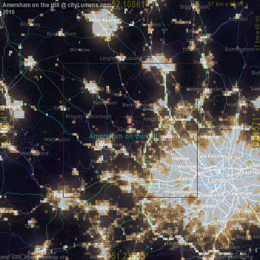
Analysis of Amersham on the Hill night lights 2016
Square area 10x10 km:
 0%
0%90-99
1.12%80-89
1.68%70-79
1.4%60-69
1.96%50-59
1.96%40-49
4.34%30-39
3.5%20-29
1.4%10-19
23.53%0-9
59.1%Square area 50x50 km:
8.01%90-99
7.98%80-89
3.37%70-79
2.85%60-69
3.78%50-59
4.31%40-49
4.52%30-39
5.17%20-29
7.83%10-19
13.44%0-9
38.74%Clear (daylight) street map image can be seen on geolist.org.
Map coordinates:
52° 6' 31" North, 1° 18' 37.9" West
51° 40' 28.8" North, 0° 36' 26.7" West
51° 14' 11.6" North, 0° 5' 44.6" East
Some cities around Amersham on the Hill sort by population:
• Chesham
2.9 km =1.8 mi,  10°
10°
• Chalfont Saint Peter
8.1 km =5 mi,  154°
154°
• Beaconsfield
7.5 km =4.7 mi,  201°
201°
• Rickmansworth
9.8 km =6.1 mi,  113°
113°
• Chorleywood
6.8 km =4.2 mi, 109°
• Chalfont St Giles
5.4 km =3.4 mi, 151°
• Great Missenden
7.7 km =4.8 mi,  295°
295°
• Bovingdon
7.3 km =4.5 mi,  42°
42°
6690592 (p: 17,719)
Sources (retrieved 2019-11-25):
» Earth at Night: Flat Maps 2012, 2016