Bovingdon night lights from space
Night Light of Bovingdon (England) from space (United Kingdom) Src. Average luminocity for 10x10km area is 18.0868% and for 50x50km: 34.651%.
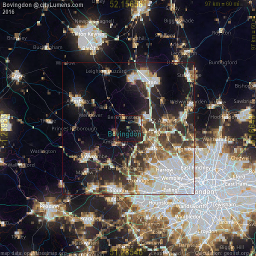
Analysis of Bovingdon night lights 2016
Square area 10x10 km:
 0.98%
0.98%90-99
0.98%80-89
1.4%70-79
1.12%60-69
0.84%50-59
3.78%40-49
4.9%30-39
4.9%20-29
8.12%10-19
18.63%0-9
54.34%Square area 50x50 km:
8.43%90-99
7.52%80-89
3.21%70-79
3.02%60-69
4.26%50-59
4.32%40-49
4.33%30-39
5.36%20-29
8.44%10-19
14.12%0-9
36.99%Clear (daylight) street map image can be seen on geolist.org.
Map coordinates:
52° 9' 23.7" North, 1° 14' 23.4" West
51° 43' 23.2" North, 0° 32' 12.1" West
51° 17' 7.7" North, 0° 9' 59.1" East
Some cities around Bovingdon sort by population:
• Hemel Hempstead
6.9 km =4.3 mi,  60°
60°
• Berkhamsted
4.6 km =2.9 mi,  334°
334°
• Amersham
8.4 km =5.2 mi,  221°
221°
• Chesham
5.1 km =3.2 mi,  239°
239°
• Amersham on the Hill
7.3 km =4.5 mi, 222°
• Chorleywood
7.8 km =4.8 mi,  168°
168°
• Abbots Langley
8.4 km =5.2 mi,  103°
103°
• Kings Langley
6 km =3.7 mi, 99°
2655079 (p: 5,295)
Sources (retrieved 2019-11-25):
» Earth at Night: Flat Maps 2012, 2016