Alsager night lights from space
Night Light of Alsager (England) from space (United Kingdom) Src. Average luminocity for 10x10km area is 21.369% and for 50x50km: 14.1885%.
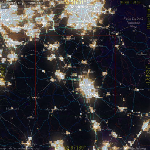
Analysis of Alsager night lights 2016
Square area 10x10 km:
 0.66%
0.66%90-99
2.25%80-89
2.91%70-79
1.72%60-69
1.59%50-59
6.22%40-49
4.37%30-39
3.57%20-29
9.13%10-19
18.65%0-9
48.94%Square area 50x50 km:
2.51%90-99
2.5%80-89
1.34%70-79
1.13%60-69
1.39%50-59
1.77%40-49
1.84%30-39
1.96%20-29
3.98%10-19
13.03%0-9
68.55%Clear (daylight) street map image can be seen on geolist.org.
Map coordinates:
53° 30' 58.7" North, 3° 0' 34.6" West
53° 5' 46.2" North, 2° 18' 23.4" West
52° 40' 18.8" North, 1° 36' 12.1" West
Some cities around Alsager sort by population:
• Newcastle under Lyme
11.8 km =7.3 mi,  155°
155°
• Crewe
9 km =5.6 mi,  271°
271°
• Kidsgrove
4.7 km =2.9 mi,  102°
102°
• Congleton
9.7 km =6 mi,  40°
40°
• Sandbach
6.6 km =4.1 mi,  325°
325°
• Biddulph
9 km =5.6 mi,  74°
74°
• Tunstall
7.6 km =4.7 mi,  123°
123°
• Audley
5.2 km =3.2 mi,  175°
175°
2657430 (p: 13,347)
Sources (retrieved 2019-11-25):
» Earth at Night: Flat Maps 2012, 2016