Aldridge night lights from space
Night Light of Aldridge (England) from space (United Kingdom) Src. Average luminocity for 10x10km area is 69.0741% and for 50x50km: 42.1899%.
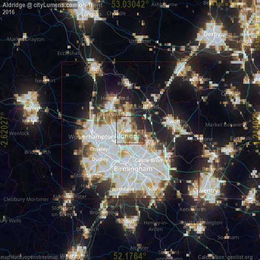
Analysis of Aldridge night lights 2016
Square area 10x10 km:
 14.81%
90-99
18.65%80-89
7.67%70-79
10.58%60-69
12.3%50-59
8.2%40-49
12.57%30-39
2.65%20-29
10.98%10-19
1.59%0-9
0%Square area 50x50 km:
13.29%90-99
11.2%80-89
3.69%70-79
3.98%60-69
3.93%50-59
3.15%40-49
3.69%30-39
3.39%20-29
7.07%10-19
16.2%0-9
30.4%Clear (daylight) street map image can be seen on geolist.org.
Map coordinates:
53° 1' 49.5" North, 2° 37' 13" West
52° 36' 19.8" North, 1° 55' 1.7" West
52° 10' 35" North, 1° 12' 50.5" West
Some cities around Aldridge sort by population:
• Walsall
5 km =3.1 mi,  243°
243°
• Sutton Coldfield
8 km =5 mi,  122°
122°
• Bloxwich
6 km =3.7 mi,  283°
283°
• Brownhills
3.3 km =2.1 mi,  340°
340°
• Streetly
3.4 km =2.1 mi,  137°
137°
• Pelsall
4.3 km =2.7 mi,  307°
307°
• Chasetown
7.5 km =4.7 mi,  355°
355°
• Norton Canes
7.9 km =4.9 mi, 337°
2657528 (p: 16,008)
Sources (retrieved 2019-11-25):
» Earth at Night: Flat Maps 2012, 2016