Chasetown night lights from space
Night Light of Chasetown (England) from space (United Kingdom) Src. Average luminocity for 10x10km area is 45.828% and for 50x50km: 36.1506%.
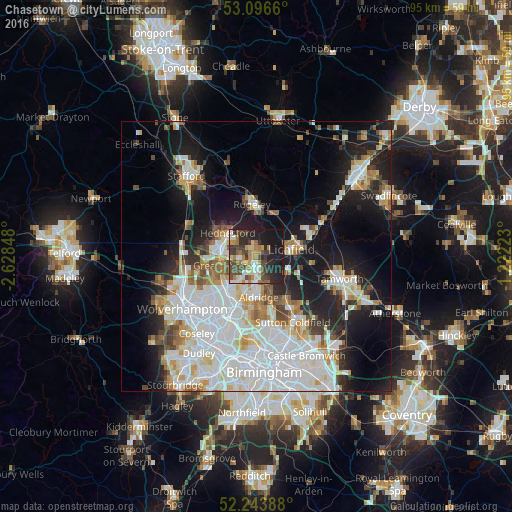
Analysis of Chasetown night lights 2016
Square area 10x10 km:
 5.82%
5.82%90-99
6.75%80-89
5.03%70-79
7.41%60-69
8.47%50-59
3.04%40-49
13.62%30-39
8.86%20-29
16.27%10-19
23.94%0-9
0.79%Square area 50x50 km:
11.69%90-99
9.17%80-89
3.03%70-79
3.32%60-69
3.33%50-59
2.61%40-49
3.15%30-39
2.54%20-29
6.12%10-19
15.73%0-9
39.31%Clear (daylight) street map image can be seen on geolist.org.
Map coordinates:
53° 5' 47.8" North, 2° 37' 42.5" West
52° 40' 20.4" North, 1° 55' 31.3" West
52° 14' 38" North, 1° 13' 20" West
Some cities around Chasetown sort by population:
• Cannock
7.4 km =4.6 mi,  285°
285°
• Lichfield
6.8 km =4.2 mi,  81°
81°
• Burntwood
0.9 km =0.6 mi,  350°
350°
• Brownhills
4.4 km =2.7 mi,  187°
187°
• Great Wyrley
5.9 km =3.7 mi,  259°
259°
• Aldridge
7.5 km =4.7 mi,  175°
175°
• Pelsall
5.6 km =3.5 mi,  210°
210°
• Norton Canes
2.5 km =1.6 mi,  267°
267°
2653307 (p: 9,000)
Sources (retrieved 2019-11-25):
» Earth at Night: Flat Maps 2012, 2016