Streetly night lights from space
Night Light of Streetly (England) from space (United Kingdom) Src. Average luminocity for 10x10km area is 70.5132% and for 50x50km: 43.7378%.
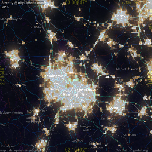
Analysis of Streetly night lights 2016
Square area 10x10 km:
 14.42%
90-99
18.78%80-89
8.07%70-79
12.3%60-69
14.29%50-59
9.66%40-49
8.73%30-39
2.25%20-29
10.05%10-19
1.46%0-9
0%Square area 50x50 km:
13.4%90-99
11.29%80-89
3.82%70-79
4.15%60-69
4.14%50-59
3.39%40-49
3.99%30-39
3.95%20-29
8.55%10-19
17.21%0-9
26.1%Clear (daylight) street map image can be seen on geolist.org.
Map coordinates:
53° 0' 30.5" North, 2° 35' 11.3" West
52° 34' 60" North, 1° 52' 60" West
52° 9' 14.5" North, 1° 10' 48.8" West
Some cities around Streetly sort by population:
• Walsall
6.8 km =4.2 mi,  271°
271°
• Sutton Coldfield
4.9 km =3 mi,  112°
112°
• Bloxwich
9 km =5.6 mi,  295°
295°
• Aston
9.3 km =5.8 mi,  180°
180°
• Brownhills
6.5 km =4 mi,  328°
328°
• Aldridge
3.4 km =2.1 mi,  317°
317°
• Pelsall
7.6 km =4.7 mi,  311°
311°
• Castle Vale
9.3 km =5.8 mi,  140°
140°
2636670 (p: 13,251)
Sources (retrieved 2019-11-25):
» Earth at Night: Flat Maps 2012, 2016