Vaujours night lights from space
Night Light of Vaujours (Île-de-France) from space (France) Src. Average luminocity for 10x10km area is 91.5398% and for 50x50km: 57.3542%.
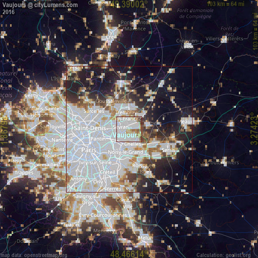
Analysis of Vaujours night lights 2016
Square area 10x10 km:
 49.15%
90-99
25.99%80-89
8.38%70-79
4.55%60-69
4.55%50-59
3.84%40-49
2.7%30-39
0.85%20-29
0%10-19
0%0-9
0%Square area 50x50 km:
28.04%90-99
12.51%80-89
3.51%70-79
2.97%60-69
3.77%50-59
3.56%40-49
3.3%30-39
4.38%20-29
7.62%10-19
15.03%0-9
15.31%Clear (daylight) street map image can be seen on geolist.org.
Map coordinates:
49° 23' 24.1" North, 1° 52' 4.7" East
48° 55' 48.8" North, 2° 34' 16" East
48° 27' 58.1" North, 3° 16' 27.2" East
Some cities around Vaujours sort by population:
• Sevran
3.6 km =2.2 mi,  296°
296°
• Livry-Gargan
2.4 km =1.5 mi,  239°
239°
• Villepinte
4.5 km =2.8 mi,  321°
321°
• Tremblay-en-France
2.2 km =1.4 mi,  354°
354°
• Clichy-sous-Bois
2.6 km =1.6 mi,  210°
210°
• Villeparisis
3.4 km =2.1 mi,  67°
67°
• Montfermeil
3.6 km =2.2 mi,  170°
170°
• Courtry
2.7 km =1.7 mi,  117°
117°
2970469 (p: 5,922)
Sources (retrieved 2019-11-25):
» Earth at Night: Flat Maps 2012, 2016