Courtry night lights from space
Night Light of Courtry (Île-de-France) from space (France) Src. Average luminocity for 10x10km area is 82.8253% and for 50x50km: 54.9685%.
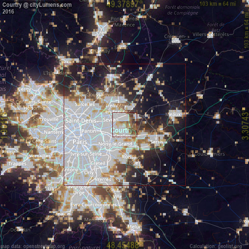
Analysis of Courtry night lights 2016
Square area 10x10 km:
 33.52%
90-99
25.14%80-89
7.81%70-79
4.55%60-69
6.25%50-59
11.08%40-49
5.68%30-39
5.82%20-29
0.14%10-19
0%0-9
0%Square area 50x50 km:
26.9%90-99
11.78%80-89
3.31%70-79
2.79%60-69
3.57%50-59
3.55%40-49
3.33%30-39
4.21%20-29
7.09%10-19
15.18%0-9
18.29%Clear (daylight) street map image can be seen on geolist.org.
Map coordinates:
49° 22' 44.3" North, 1° 54' 4.2" East
48° 55' 8.6" North, 2° 36' 15.5" East
48° 27' 17.6" North, 3° 18' 26.7" East
Some cities around Courtry sort by population:
• Chelles
4.3 km =2.7 mi,  191°
191°
• Livry-Gargan
4.5 km =2.8 mi,  270°
270°
• Tremblay-en-France
4.3 km =2.7 mi,  322°
322°
• Clichy-sous-Bois
3.9 km =2.4 mi,  255°
255°
• Villeparisis
2.7 km =1.7 mi,  16°
16°
• Montfermeil
3 km =1.9 mi,  218°
218°
• Vaires-sur-Marne
5.4 km =3.4 mi,  151°
151°
• Vaujours
2.7 km =1.7 mi,  297°
297°
3022868 (p: 6,610)
Sources (retrieved 2019-11-25):
» Earth at Night: Flat Maps 2012, 2016