Sérignan night lights from space
Night Light of Sérignan (Occitanie) from space (France) Src. Average luminocity for 10x10km area is 31.0182% and for 50x50km: 14.1737%.
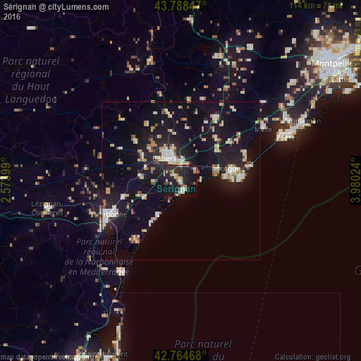
Analysis of Sérignan night lights 2016
Square area 10x10 km:
 1.36%
1.36%90-99
5.76%80-89
5.3%70-79
2.73%60-69
5%50-59
0.76%40-49
4.39%30-39
4.55%20-29
18.64%10-19
35.76%0-9
15.76%Square area 50x50 km:
1.43%90-99
3.13%80-89
1.69%70-79
1.37%60-69
1.56%50-59
0.85%40-49
1.18%30-39
1.01%20-29
4.04%10-19
14.92%0-9
68.81%Clear (daylight) street map image can be seen on geolist.org.
Map coordinates:
43° 47' 18.5" North, 2° 34' 26.4" East
43° 16' 43.4" North, 3° 16' 37.6" East
42° 45' 52.8" North, 3° 58' 48.9" East
Some cities around Sérignan sort by population:
• Béziers
8.6 km =5.3 mi,  323°
323°
• Narbonne
24.7 km =15.3 mi,  244°
244°
• Agde
16.5 km =10.3 mi,  77°
77°
• Pézenas
23.3 km =14.5 mi,  30°
30°
• Mèze
31.2 km =19.4 mi,  58°
58°
• Marseillan
22 km =13.7 mi,  67°
67°
• Coursan
18.5 km =11.5 mi,  254°
254°
• Port-la-Nouvelle
34.5 km =21.4 mi,  213°
213°
2974925 (p: 6,936)
Sources (retrieved 2019-11-25):
» Earth at Night: Flat Maps 2012, 2016