Pézenas night lights from space
Night Light of Pézenas (Occitanie) from space (France) Src. Average luminocity for 10x10km area is 21.5159% and for 50x50km: 17.0369%.
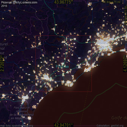
Analysis of Pézenas night lights 2016
Square area 10x10 km:
 0.95%
0.95%90-99
6.98%80-89
2.22%70-79
2.22%60-69
0.95%50-59
0.95%40-49
0.95%30-39
2.54%20-29
3.02%10-19
33.33%0-9
45.87%Square area 50x50 km:
1.72%90-99
3.68%80-89
2.05%70-79
1.73%60-69
1.98%50-59
1.17%40-49
1.38%30-39
1.19%20-29
5.23%10-19
18.72%0-9
61.15%Clear (daylight) street map image can be seen on geolist.org.
Map coordinates:
43° 58' 3.9" North, 2° 43' 14.6" East
43° 27' 34.3" North, 3° 25' 25.8" East
42° 56' 49.2" North, 4° 7' 37.1" East
Some cities around Pézenas sort by population:
• Béziers
21.5 km =13.4 mi,  232°
232°
• Sète
22.6 km =14 mi,  106°
106°
• Agde
17.1 km =10.6 mi,  165°
165°
• Mèze
15.2 km =9.4 mi,  104°
104°
• Marseillan
14.2 km =8.8 mi,  143°
143°
• Sérignan
23.3 km =14.5 mi,  210°
210°
• Balaruc-les-Bains
20.6 km =12.8 mi, 95°
• Gignac
23.7 km =14.7 mi,  25°
25°
2987441 (p: 8,647)
Sources (retrieved 2019-11-25):
» Earth at Night: Flat Maps 2012, 2016