Marseillan night lights from space
Night Light of Marseillan (Occitanie) from space (France) Src. Average luminocity for 10x10km area is 22.9206% and for 50x50km: 14.2854%.
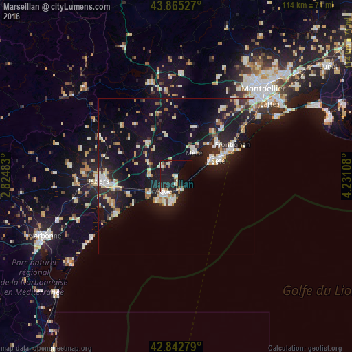
Analysis of Marseillan night lights 2016
Square area 10x10 km:
 2.22%
2.22%90-99
4.92%80-89
2.06%70-79
2.54%60-69
1.75%50-59
1.9%40-49
2.06%30-39
1.11%20-29
12.7%10-19
28.73%0-9
40%Square area 50x50 km:
1.58%90-99
3.16%80-89
1.76%70-79
1.31%60-69
1.52%50-59
0.93%40-49
1.06%30-39
1.21%20-29
4.96%10-19
15.29%0-9
67.21%Clear (daylight) street map image can be seen on geolist.org.
Map coordinates:
43° 51' 55" North, 2° 49' 29.4" East
43° 21' 22.2" North, 3° 31' 40.6" East
42° 50' 34" North, 4° 13' 51.9" East
Some cities around Marseillan sort by population:
• Béziers
25.4 km =15.8 mi,  266°
266°
• Sète
14.3 km =8.9 mi,  68°
68°
• Agde
6.6 km =4.1 mi,  219°
219°
• Frontignan
20.9 km =13 mi,  60°
60°
• Pézenas
14.2 km =8.8 mi,  323°
323°
• Mèze
9.9 km =6.2 mi,  39°
39°
• Sérignan
22 km =13.7 mi,  247°
247°
• Balaruc-les-Bains
15.4 km =9.6 mi,  51°
51°
2995471 (p: 6,981)
Sources (retrieved 2019-11-25):
» Earth at Night: Flat Maps 2012, 2016