Roye night lights from space
Night Light of Roye (Hauts-de-France) from space (France) Src. Average luminocity for 10x10km area is 10.357% and for 50x50km: 5.1414%.
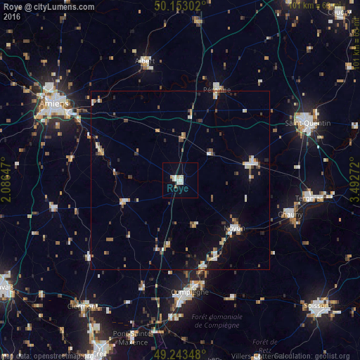
Analysis of Roye night lights 2016
Square area 10x10 km:
 1.87%
1.87%90-99
3.88%80-89
0.67%70-79
1.07%60-69
0.27%50-59
0.27%40-49
0%30-39
0%20-29
0.94%10-19
1.07%0-9
89.97%Square area 50x50 km:
0.61%90-99
0.9%80-89
0.47%70-79
0.51%60-69
0.53%50-59
0.74%40-49
0.58%30-39
0.68%20-29
0.67%10-19
2.57%0-9
91.73%Clear (daylight) street map image can be seen on geolist.org.
Map coordinates:
50° 9' 10.9" North, 2° 5' 11.3" East
49° 42' 1.4" North, 2° 47' 22.5" East
49° 14' 36.5" North, 3° 29' 33.8" East
Some cities around Roye sort by population:
• Compiègne
31.5 km =19.6 mi,  175°
175°
• Noyon
20 km =12.4 mi,  130°
130°
• Péronne
27.8 km =17.3 mi,  22°
22°
• Margny-lès-Compiègne
30.6 km =19 mi, 176°
• Montdidier
16.8 km =10.4 mi,  249°
249°
• Corbie
30.6 km =19 mi,  318°
318°
• Ham
21 km =13 mi,  75°
75°
• Thourotte
25.8 km =16 mi,  165°
165°
2982330 (p: 6,655)
Sources (retrieved 2019-11-25):
» Earth at Night: Flat Maps 2012, 2016