Thourotte night lights from space
Night Light of Thourotte (Hauts-de-France) from space (France) Src. Average luminocity for 10x10km area is 28.3683% and for 50x50km: 7.6547%.
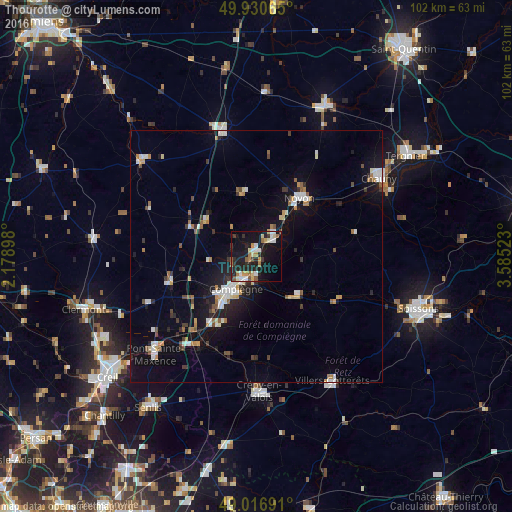
Analysis of Thourotte night lights 2016
Square area 10x10 km:
 4.34%
4.34%90-99
4.2%80-89
3.36%70-79
2.94%60-69
3.92%50-59
3.22%40-49
1.68%30-39
3.64%20-29
10.64%10-19
34.59%0-9
27.45%Square area 50x50 km:
1.11%90-99
1.24%80-89
0.52%70-79
0.73%60-69
0.94%50-59
0.78%40-49
0.62%30-39
0.9%20-29
1.79%10-19
6.49%0-9
84.88%Clear (daylight) street map image can be seen on geolist.org.
Map coordinates:
49° 55' 50.3" North, 2° 10' 44.3" East
49° 28' 33.3" North, 2° 52' 55.6" East
49° 1' 0.9" North, 3° 35' 6.8" East
Some cities around Thourotte sort by population:
• Compiègne
7.6 km =4.7 mi,  212°
212°
• Crépy-en-Valois
26.9 km =16.7 mi,  179°
179°
• Noyon
14.7 km =9.1 mi,  35°
35°
• Pont-Sainte-Maxence
27.9 km =17.3 mi,  226°
226°
• Chauny
28.8 km =17.9 mi,  57°
57°
• Villers-Cotterêts
29 km =18 mi,  148°
148°
• Margny-lès-Compiègne
7.3 km =4.5 mi,  219°
219°
• Roye
25.8 km =16 mi,  345°
345°
2972684 (p: 5,581)
Sources (retrieved 2019-11-25):
» Earth at Night: Flat Maps 2012, 2016