Ham night lights from space
Night Light of Ham (Hauts-de-France) from space (France) Src. Average luminocity for 10x10km area is 14.5374% and for 50x50km: 7.9313%.
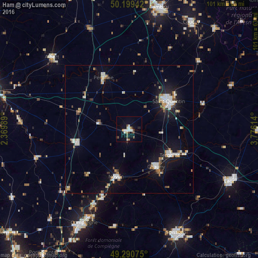
Analysis of Ham night lights 2016
Square area 10x10 km:
 2.54%
2.54%90-99
2.94%80-89
1.74%70-79
0.67%60-69
0.67%50-59
2.14%40-49
2.14%30-39
1.34%20-29
1.47%10-19
7.75%0-9
76.6%Square area 50x50 km:
1.32%90-99
1.52%80-89
0.61%70-79
0.74%60-69
0.79%50-59
0.9%40-49
0.66%30-39
0.66%20-29
1.36%10-19
6.46%0-9
84.98%Clear (daylight) street map image can be seen on geolist.org.
Map coordinates:
50° 11' 57.9" North, 2° 22' 11.6" East
49° 44' 50" North, 3° 4' 22.8" East
49° 17' 26.7" North, 3° 46' 34.1" East
Some cities around Ham sort by population:
• Saint-Quentin
19.1 km =11.9 mi,  53°
53°
• Tergnier
19.3 km =12 mi,  121°
121°
• Noyon
19 km =11.8 mi,  196°
196°
• Chauny
18 km =11.2 mi,  144°
144°
• Péronne
22.8 km =14.2 mi,  334°
334°
• Roye
21 km =13 mi,  255°
255°
• Gauchy
17 km =10.6 mi,  58°
58°
• Thourotte
33.2 km =20.6 mi, 204°
3014029 (p: 5,698)
Sources (retrieved 2019-11-25):
» Earth at Night: Flat Maps 2012, 2016