Noyon night lights from space
Night Light of Noyon (Hauts-de-France) from space (France) Src. Average luminocity for 10x10km area is 18.6218% and for 50x50km: 9.0273%.
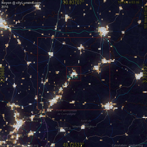
Analysis of Noyon night lights 2016
Square area 10x10 km:
 2.8%
2.8%90-99
3.78%80-89
1.26%70-79
2.66%60-69
1.96%50-59
2.66%40-49
0%30-39
1.96%20-29
1.82%10-19
21.01%0-9
60.08%Square area 50x50 km:
1.53%90-99
1.62%80-89
0.69%70-79
0.78%60-69
0.99%50-59
0.97%40-49
0.75%30-39
0.7%20-29
2%10-19
8.68%0-9
81.29%Clear (daylight) street map image can be seen on geolist.org.
Map coordinates:
50° 2' 13.5" North, 2° 17' 48.8" East
49° 34' 60" North, 3° 0' 0" East
49° 7' 31.2" North, 3° 42' 11.3" East
Some cities around Noyon sort by population:
• Compiègne
22.3 km =13.9 mi,  214°
214°
• Tergnier
23.1 km =14.4 mi,  69°
69°
• Chauny
16.1 km =10 mi,  77°
77°
• Margny-lès-Compiègne
21.9 km =13.6 mi,  216°
216°
• Roye
20 km =12.4 mi,  310°
310°
• Montdidier
31.8 km =19.8 mi,  283°
283°
• Ham
19 km =11.8 mi,  16°
16°
• Thourotte
14.7 km =9.1 mi, 215°
2989877 (p: 15,138)
Sources (retrieved 2019-11-25):
» Earth at Night: Flat Maps 2012, 2016