Gignac night lights from space
Night Light of Gignac (Occitanie) from space (France) Src. Average luminocity for 10x10km area is 16.2742% and for 50x50km: 12.8901%.
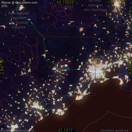
Analysis of Gignac night lights 2016
Square area 10x10 km:
 1.82%
1.82%90-99
3.48%80-89
0.3%70-79
2.88%60-69
1.97%50-59
2.27%40-49
1.82%30-39
0%20-29
0%10-19
20.15%0-9
65.3%Square area 50x50 km:
1.93%90-99
2.68%80-89
1.36%70-79
1.12%60-69
1.67%50-59
1.19%40-49
1.04%30-39
1.61%20-29
3.45%10-19
10.27%0-9
73.68%Clear (daylight) street map image can be seen on geolist.org.
Map coordinates:
44° 9' 30.9" North, 2° 50' 52" East
43° 39' 7.2" North, 3° 33' 3.2" East
43° 8' 28" North, 4° 15' 14.5" East
Some cities around Gignac sort by population:
• Saint-Gély-du-Fesc
20.9 km =13 mi,  77°
77°
• Lodève
20.6 km =12.8 mi,  295°
295°
• Fabrègues
21.4 km =13.3 mi,  121°
121°
• Pignan
18.5 km =11.5 mi,  114°
114°
• Juvignac
21.3 km =13.2 mi,  101°
101°
• Grabels
19.9 km =12.4 mi,  91°
91°
• Cournonterral
17.1 km =10.6 mi,  127°
127°
• Saint-Clément-de-Rivière
23 km =14.3 mi, 81°
3016073 (p: 5,025)
Sources (retrieved 2019-11-25):
» Earth at Night: Flat Maps 2012, 2016