Balaruc-les-Bains night lights from space
Night Light of Balaruc-les-Bains (Occitanie) from space (France) Src. Average luminocity for 10x10km area is 44.3571% and for 50x50km: 19.5225%.
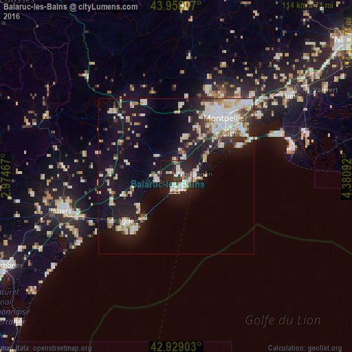
Analysis of Balaruc-les-Bains night lights 2016
Square area 10x10 km:
 9.52%
9.52%90-99
11.59%80-89
4.6%70-79
4.76%60-69
1.75%50-59
1.59%40-49
3.33%30-39
3.49%20-29
30.16%10-19
28.57%0-9
0.63%Square area 50x50 km:
4%90-99
4.57%80-89
1.94%70-79
1.93%60-69
1.9%50-59
1.38%40-49
1.29%30-39
1.97%20-29
5.08%10-19
16.52%0-9
59.41%Clear (daylight) street map image can be seen on geolist.org.
Map coordinates:
43° 57' 0.3" North, 2° 58' 28.8" East
43° 26' 30.1" North, 3° 40' 40.1" East
42° 55' 44.5" North, 4° 22' 51.3" East
Some cities around Balaruc-les-Bains sort by population:
• Sète
4.5 km =2.8 mi,  164°
164°
• Frontignan
6.2 km =3.9 mi,  83°
83°
• Mèze
6.1 km =3.8 mi,  252°
252°
• Villeneuve-lès-Maguelone
18.3 km =11.4 mi,  56°
56°
• Marseillan
15.4 km =9.6 mi,  231°
231°
• Fabrègues
14.5 km =9 mi,  33°
33°
• Pignan
17.1 km =10.6 mi,  22°
22°
• Cournonterral
13.5 km =8.4 mi,  14°
14°
3035268 (p: 6,387)
Sources (retrieved 2019-11-25):
» Earth at Night: Flat Maps 2012, 2016