Montigny-en-Gohelle night lights from space
Night Light of Montigny-en-Gohelle (Hauts-de-France) from space (France) Src. Average luminocity for 10x10km area is 85.4286% and for 50x50km: 43.1596%.
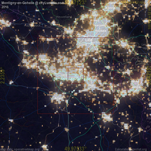
Analysis of Montigny-en-Gohelle night lights 2016
Square area 10x10 km:
 30.53%
90-99
29.55%80-89
10.64%70-79
9.8%60-69
5.46%50-59
3.36%40-49
6.44%30-39
4.2%20-29
0%10-19
0%0-9
0%Square area 50x50 km:
9.79%90-99
9.93%80-89
3.71%70-79
4.52%60-69
5.35%50-59
5.01%40-49
5.94%30-39
6.95%20-29
11.73%10-19
18.33%0-9
18.72%Clear (daylight) street map image can be seen on geolist.org.
Map coordinates:
50° 52' 16.4" North, 2° 14' 9.2" East
50° 25' 31.4" North, 2° 56' 20.5" East
49° 58' 31.2" North, 3° 38' 31.7" East
Some cities around Montigny-en-Gohelle sort by population:
• Hénin-Beaumont
2.3 km =1.4 mi,  125°
125°
• Harnes
3.4 km =2.1 mi,  313°
313°
• Courrières
3.6 km =2.2 mi,  9°
9°
• Rouvroy
4.4 km =2.7 mi,  214°
214°
• Billy-Montigny
2.7 km =1.7 mi,  250°
250°
• Fouquières-lès-Lens
1.9 km =1.2 mi,  280°
280°
• Dourges
3.5 km =2.2 mi,  69°
69°
• Noyelles-Godault
3.9 km =2.4 mi,  102°
102°
2992420 (p: 10,713)
Sources (retrieved 2019-11-25):
» Earth at Night: Flat Maps 2012, 2016