Fouquières-lès-Lens night lights from space
Night Light of Fouquières-lès-Lens (Hauts-de-France) from space (France) Src. Average luminocity for 10x10km area is 88.5798% and for 50x50km: 43.2422%.
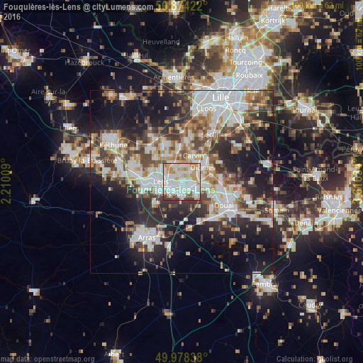
Analysis of Fouquières-lès-Lens night lights 2016
Square area 10x10 km:
 32.91%
90-99
32.21%80-89
9.8%70-79
11.76%60-69
5.6%50-59
2.66%40-49
2.1%30-39
2.94%20-29
0%10-19
0%0-9
0%Square area 50x50 km:
9.96%90-99
9.92%80-89
3.79%70-79
4.55%60-69
5.46%50-59
4.98%40-49
6.02%30-39
6.9%20-29
11.29%10-19
17.59%0-9
19.54%Clear (daylight) street map image can be seen on geolist.org.
Map coordinates:
50° 52' 27.2" North, 2° 12' 36.3" East
50° 25' 42.3" North, 2° 54' 47.6" East
49° 58' 42.2" North, 3° 36' 58.8" East
Some cities around Fouquières-lès-Lens sort by population:
• Hénin-Beaumont
4 km =2.5 mi,  114°
114°
• Harnes
2.1 km =1.3 mi,  343°
343°
• Montigny-en-Gohelle
1.9 km =1.2 mi,  100°
100°
• Sallaumines
3.8 km =2.4 mi,  251°
251°
• Courrières
4 km =2.5 mi,  37°
37°
• Rouvroy
4.1 km =2.5 mi,  189°
189°
• Billy-Montigny
1.5 km =0.9 mi,  210°
210°
• Noyelles-sous-Lens
2.9 km =1.8 mi,  275°
275°
3017556 (p: 7,008)
Sources (retrieved 2019-11-25):
» Earth at Night: Flat Maps 2012, 2016