Billy-Montigny night lights from space
Night Light of Billy-Montigny (Hauts-de-France) from space (France) Src. Average luminocity for 10x10km area is 81.8754% and for 50x50km: 41.695%.
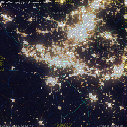
Analysis of Billy-Montigny night lights 2016
Square area 10x10 km:
 30.95%
90-99
29.41%80-89
7.56%70-79
7.56%60-69
3.64%50-59
2.38%40-49
2.94%30-39
13.73%20-29
1.82%10-19
0%0-9
0%Square area 50x50 km:
9.32%90-99
9.77%80-89
3.68%70-79
4.3%60-69
5.26%50-59
4.8%40-49
5.75%30-39
6.77%20-29
11.09%10-19
17.16%0-9
22.07%Clear (daylight) street map image can be seen on geolist.org.
Map coordinates:
50° 51' 46.9" North, 2° 11' 59.1" East
50° 25' 1.6" North, 2° 54' 10.3" East
49° 58' 1.1" North, 3° 36' 21.6" East
Some cities around Billy-Montigny sort by population:
• Harnes
3.3 km =2.1 mi,  2°
2°
• Méricourt
3.4 km =2.1 mi,  238°
238°
• Montigny-en-Gohelle
2.7 km =1.7 mi,  70°
70°
• Sallaumines
2.9 km =1.8 mi,  270°
270°
• Rouvroy
2.7 km =1.7 mi,  178°
178°
• Noyelles-sous-Lens
2.7 km =1.7 mi,  305°
305°
• Fouquières-lès-Lens
1.5 km =0.9 mi,  30°
30°
• Loison-sous-Lens
4.2 km =2.6 mi,  303°
303°
3032618 (p: 8,533)
Sources (retrieved 2019-11-25):
» Earth at Night: Flat Maps 2012, 2016