Noyelles-Godault night lights from space
Night Light of Noyelles-Godault (Hauts-de-France) from space (France) Src. Average luminocity for 10x10km area is 79.2395% and for 50x50km: 42.6988%.
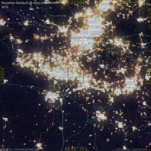
Analysis of Noyelles-Godault night lights 2016
Square area 10x10 km:
 23.81%
90-99
25.21%80-89
7.56%70-79
9.8%60-69
12.89%50-59
4.34%40-49
7.56%30-39
8.4%20-29
0.42%10-19
0%0-9
0%Square area 50x50 km:
9.31%90-99
9.71%80-89
3.75%70-79
4.32%60-69
5.41%50-59
5%40-49
5.96%30-39
6.88%20-29
12.33%10-19
18.94%0-9
18.37%Clear (daylight) street map image can be seen on geolist.org.
Map coordinates:
50° 51' 48.4" North, 2° 17' 23.8" East
50° 25' 3.1" North, 2° 59' 35" East
49° 58' 2.6" North, 3° 41' 46.3" East
Some cities around Noyelles-Godault sort by population:
• Hénin-Beaumont
2 km =1.2 mi,  257°
257°
• Montigny-en-Gohelle
3.9 km =2.4 mi,  282°
282°
• Oignies
5.1 km =3.2 mi,  0°
0°
• Auby
4.3 km =2.7 mi,  94°
94°
• Courcelles-lès-Lens
1.7 km =1.1 mi, 93°
• Dourges
2.2 km =1.4 mi,  346°
346°
• Flers-en-Escrebieux
5.2 km =3.2 mi,  114°
114°
• Ostricourt
4.8 km =3 mi,  37°
37°
2989901 (p: 5,624)
Sources (retrieved 2019-11-25):
» Earth at Night: Flat Maps 2012, 2016