Dourges night lights from space
Night Light of Dourges (Hauts-de-France) from space (France) Src. Average luminocity for 10x10km area is 85.0462% and for 50x50km: 44.9639%.
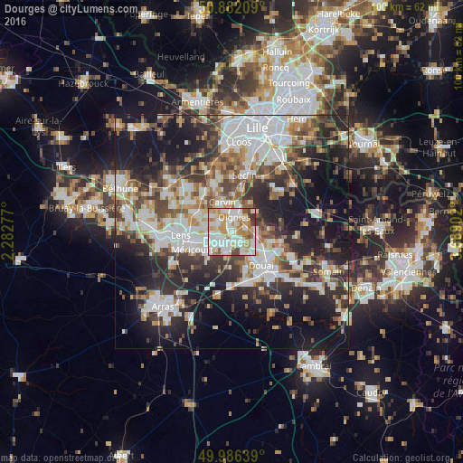
Analysis of Dourges night lights 2016
Square area 10x10 km:
 28.01%
90-99
27.45%80-89
9.24%70-79
14.15%60-69
11.62%50-59
3.36%40-49
3.92%30-39
2.24%20-29
0%10-19
0%0-9
0%Square area 50x50 km:
10.42%90-99
10.03%80-89
3.88%70-79
4.67%60-69
5.59%50-59
5.2%40-49
6.32%30-39
7.14%20-29
12.68%10-19
18.97%0-9
15.1%Clear (daylight) street map image can be seen on geolist.org.
Map coordinates:
50° 52' 55.5" North, 2° 16' 58" East
50° 26' 10.9" North, 2° 59' 9.2" East
49° 59' 11" North, 3° 41' 20.5" East
Some cities around Dourges sort by population:
• Hénin-Beaumont
2.9 km =1.8 mi,  210°
210°
• Montigny-en-Gohelle
3.5 km =2.2 mi,  249°
249°
• Oignies
3 km =1.9 mi,  10°
10°
• Courrières
3.6 km =2.2 mi,  310°
310°
• Fouquières-lès-Lens
5.2 km =3.2 mi,  260°
260°
• Courcelles-lès-Lens
3.1 km =1.9 mi,  135°
135°
• Noyelles-Godault
2.2 km =1.4 mi,  166°
166°
• Ostricourt
3.8 km =2.4 mi,  63°
63°
3020917 (p: 5,761)
Sources (retrieved 2019-11-25):
» Earth at Night: Flat Maps 2012, 2016