Rouvroy night lights from space
Night Light of Rouvroy (Hauts-de-France) from space (France) Src. Average luminocity for 10x10km area is 64.5924% and for 50x50km: 39.3858%.
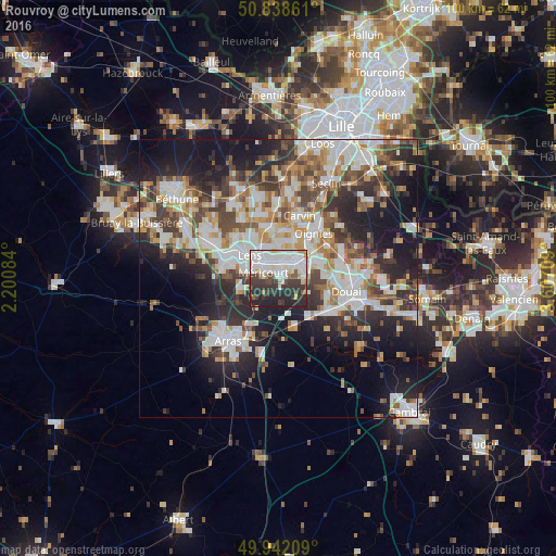
Analysis of Rouvroy night lights 2016
Square area 10x10 km:
 21.29%
90-99
21.99%80-89
3.36%70-79
2.8%60-69
2.52%50-59
3.64%40-49
4.76%30-39
17.51%20-29
19.05%10-19
3.08%0-9
0%Square area 50x50 km:
8.3%90-99
9.44%80-89
3.58%70-79
4.03%60-69
5.13%50-59
4.54%40-49
5.47%30-39
6.44%20-29
10.78%10-19
16.06%0-9
26.22%Clear (daylight) street map image can be seen on geolist.org.
Map coordinates:
50° 50' 19" North, 2° 12' 3" East
50° 23' 32.9" North, 2° 54' 14.3" East
49° 56' 31.5" North, 3° 36' 25.5" East
Some cities around Rouvroy sort by population:
• Hénin-Beaumont
4.9 km =3 mi,  61°
61°
• Avion
5.6 km =3.5 mi,  290°
290°
• Méricourt
3.1 km =1.9 mi, 288°
• Montigny-en-Gohelle
4.4 km =2.7 mi,  34°
34°
• Sallaumines
4.1 km =2.5 mi,  312°
312°
• Billy-Montigny
2.7 km =1.7 mi,  358°
358°
• Noyelles-sous-Lens
4.8 km =3 mi,  332°
332°
• Fouquières-lès-Lens
4.1 km =2.5 mi,  9°
9°
2982383 (p: 9,122)
Sources (retrieved 2019-11-25):
» Earth at Night: Flat Maps 2012, 2016