Courrières night lights from space
Night Light of Courrières (Hauts-de-France) from space (France) Src. Average luminocity for 10x10km area is 87.4804% and for 50x50km: 47.1114%.
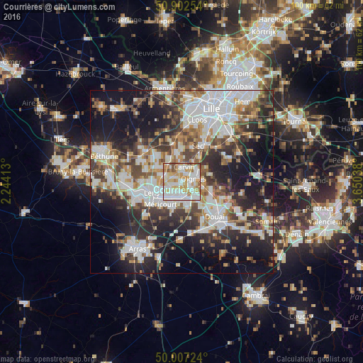
Analysis of Courrières night lights 2016
Square area 10x10 km:
 29.69%
90-99
28.43%80-89
11.76%70-79
14.85%60-69
9.52%50-59
2.94%40-49
2.8%30-39
0%20-29
0%10-19
0%0-9
0%Square area 50x50 km:
11.63%90-99
10.64%80-89
4.04%70-79
4.88%60-69
5.76%50-59
5.42%40-49
6.31%30-39
7.51%20-29
12.19%10-19
18.56%0-9
13.06%Clear (daylight) street map image can be seen on geolist.org.
Map coordinates:
50° 54' 9.1" North, 2° 14' 38.9" East
50° 27' 25.2" North, 2° 56' 50.1" East
50° 0' 26.1" North, 3° 39' 1.4" East
Some cities around Courrières sort by population:
• Hénin-Beaumont
5 km =3.1 mi,  165°
165°
• Carvin
4 km =2.5 mi,  11°
11°
• Harnes
3.2 km =2 mi,  248°
248°
• Montigny-en-Gohelle
3.6 km =2.2 mi,  189°
189°
• Oignies
3.4 km =2.1 mi,  77°
77°
• Billy-Montigny
5.4 km =3.4 mi,  215°
215°
• Fouquières-lès-Lens
4 km =2.5 mi, 217°
• Dourges
3.6 km =2.2 mi,  130°
130°
3022969 (p: 10,330)
Sources (retrieved 2019-11-25):
» Earth at Night: Flat Maps 2012, 2016