Mions night lights from space
Night Light of Mions (Auvergne-Rhône-Alpes) from space (France) Src. Average luminocity for 10x10km area is 67.0591% and for 50x50km: 36.3654%.
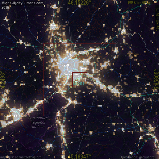
Analysis of Mions night lights 2016
Square area 10x10 km:
 20.45%
90-99
18.33%80-89
3.64%70-79
4.85%60-69
9.09%50-59
9.85%40-49
11.06%30-39
8.33%20-29
9.85%10-19
4.55%0-9
0%Square area 50x50 km:
9.09%90-99
7.57%80-89
2.69%70-79
3.6%60-69
3.91%50-59
4.73%40-49
4.55%30-39
5.75%20-29
10.59%10-19
17.39%0-9
30.13%Clear (daylight) street map image can be seen on geolist.org.
Map coordinates:
46° 9' 8.1" North, 4° 14' 59.3" East
45° 39' 46.9" North, 4° 57' 10.5" East
45° 10' 10.1" North, 5° 39' 21.8" East
Some cities around Mions sort by population:
• Vénissieux
6.4 km =4 mi,  306°
306°
• Saint-Priest
3.8 km =2.4 mi,  349°
349°
• Bron
9 km =5.6 mi,  339°
339°
• Genas
8.5 km =5.3 mi,  26°
26°
• Corbas
4 km =2.5 mi,  277°
277°
• Feyzin
7.4 km =4.6 mi, 278°
• Chassieu
9.3 km =5.8 mi,  8°
8°
• Saint-Bonnet-de-Mure
6.7 km =4.2 mi,  62°
62°
2993780 (p: 11,424)
Sources (retrieved 2019-11-25):
» Earth at Night: Flat Maps 2012, 2016