Corbas night lights from space
Night Light of Corbas (Auvergne-Rhône-Alpes) from space (France) Src. Average luminocity for 10x10km area is 79.5197% and for 50x50km: 36.0051%.
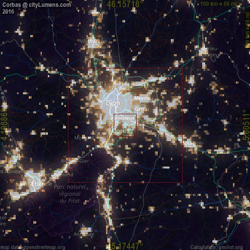
Analysis of Corbas night lights 2016
Square area 10x10 km:
 32.42%
90-99
24.24%80-89
3.94%70-79
5.61%60-69
6.52%50-59
8.18%40-49
9.7%30-39
6.67%20-29
2.58%10-19
0.15%0-9
0%Square area 50x50 km:
8.92%90-99
7.47%80-89
2.67%70-79
3.63%60-69
3.94%50-59
4.67%40-49
4.64%30-39
5.72%20-29
10.41%10-19
16.5%0-9
31.43%Clear (daylight) street map image can be seen on geolist.org.
Map coordinates:
46° 9' 25.8" North, 4° 11' 55.9" East
45° 40' 4.7" North, 4° 54' 7.1" East
45° 10' 28.1" North, 5° 36' 18.4" East
Some cities around Corbas sort by population:
• Vénissieux
3.5 km =2.2 mi,  338°
338°
• Saint-Priest
4.5 km =2.8 mi,  45°
45°
• Bron
7.9 km =4.9 mi,  6°
6°
• Saint-Fons
5.9 km =3.7 mi,  320°
320°
• Mions
4 km =2.5 mi,  97°
97°
• Pierre-Bénite
7.2 km =4.5 mi,  303°
303°
• Feyzin
3.4 km =2.1 mi,  279°
279°
• Irigny
6.2 km =3.9 mi, 275°
3023771 (p: 9,753)
Sources (retrieved 2019-11-25):
» Earth at Night: Flat Maps 2012, 2016