Feyzin night lights from space
Night Light of Feyzin (Auvergne-Rhône-Alpes) from space (France) Src. Average luminocity for 10x10km area is 82.3773% and for 50x50km: 35.6031%.
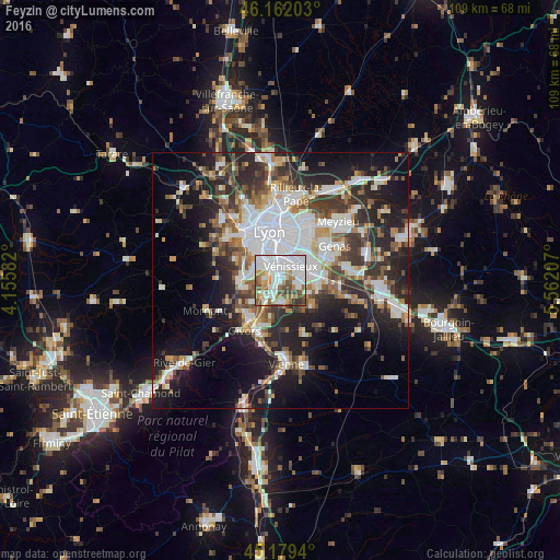
Analysis of Feyzin night lights 2016
Square area 10x10 km:
 33.03%
90-99
25.91%80-89
4.09%70-79
6.82%60-69
9.09%50-59
8.33%40-49
8.94%30-39
3.33%20-29
0.45%10-19
0%0-9
0%Square area 50x50 km:
8.86%90-99
7.54%80-89
2.68%70-79
3.61%60-69
3.81%50-59
4.53%40-49
4.63%30-39
5.63%20-29
10.23%10-19
15.36%0-9
33.13%Clear (daylight) street map image can be seen on geolist.org.
Map coordinates:
46° 9' 43.3" North, 4° 9' 21" East
45° 40' 22.3" North, 4° 51' 32.2" East
45° 10' 45.8" North, 5° 33' 43.5" East
Some cities around Feyzin sort by population:
• Vénissieux
3.4 km =2.1 mi,  37°
37°
• Saint-Priest
7.1 km =4.4 mi,  68°
68°
• Oullins
6.1 km =3.8 mi,  318°
318°
• Saint-Genis-Laval
5.7 km =3.5 mi,  296°
296°
• Saint-Fons
4 km =2.5 mi,  353°
353°
• Pierre-Bénite
4.4 km =2.7 mi, 321°
• Corbas
3.4 km =2.1 mi,  99°
99°
• Irigny
2.8 km =1.7 mi,  270°
270°
3018544 (p: 9,539)
Sources (retrieved 2019-11-25):
» Earth at Night: Flat Maps 2012, 2016