Saint-Bonnet-de-Mure night lights from space
Night Light of Saint-Bonnet-de-Mure (Auvergne-Rhône-Alpes) from space (France) Src. Average luminocity for 10x10km area is 60.7394% and for 50x50km: 36.6183%.
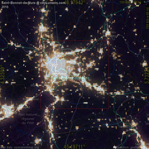
Analysis of Saint-Bonnet-de-Mure night lights 2016
Square area 10x10 km:
 11.52%
90-99
14.24%80-89
6.06%70-79
5.3%60-69
9.55%50-59
8.03%40-49
14.09%30-39
19.85%20-29
11.36%10-19
0%0-9
0%Square area 50x50 km:
9.2%90-99
7.7%80-89
2.66%70-79
3.48%60-69
3.94%50-59
4.77%40-49
4.51%30-39
5.8%20-29
10.94%10-19
16.77%0-9
30.24%Clear (daylight) street map image can be seen on geolist.org.
Map coordinates:
46° 10' 45.9" North, 4° 19' 33.6" East
45° 41' 25.5" North, 5° 1' 44.8" East
45° 11' 49.6" North, 5° 43' 56.1" East
Some cities around Saint-Bonnet-de-Mure sort by population:
• Bron
10.5 km =6.5 mi,  300°
300°
• Meyzieu
8.7 km =5.4 mi,  346°
346°
• Décines-Charpieu
10.3 km =6.4 mi,  327°
327°
• Genas
5 km =3.1 mi,  335°
335°
• Mions
6.7 km =4.2 mi,  242°
242°
• Corbas
10.2 km =6.3 mi,  255°
255°
• Chassieu
7.6 km =4.7 mi,  323°
323°
• La Verpillière
11 km =6.8 mi,  124°
124°
2981338 (p: 5,890)
Sources (retrieved 2019-11-25):
» Earth at Night: Flat Maps 2012, 2016