Menucourt night lights from space
Night Light of Menucourt (Île-de-France) from space (France) Src. Average luminocity for 10x10km area is 52.8884% and for 50x50km: 39.1306%.
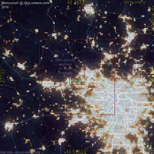
Analysis of Menucourt night lights 2016
Square area 10x10 km:
 8.63%
8.63%90-99
9.08%80-89
7.44%70-79
7.89%60-69
9.08%50-59
8.78%40-49
12.05%30-39
5.65%20-29
13.39%10-19
12.95%0-9
5.06%Square area 50x50 km:
13.06%90-99
8.59%80-89
3.25%70-79
3.57%60-69
3.77%50-59
3.6%40-49
4.8%30-39
3.85%20-29
7.89%10-19
11.44%0-9
36.19%Clear (daylight) street map image can be seen on geolist.org.
Map coordinates:
49° 29' 14.3" North, 1° 16' 38.4" East
49° 1' 42.3" North, 1° 58' 49.7" East
48° 33' 54.9" North, 2° 41' 0.9" East
Some cities around Menucourt sort by population:
• Les Mureaux
6.6 km =4.1 mi,  231°
231°
• Vauréal
3.9 km =2.4 mi,  81°
81°
• Jouy-le-Moutier
4.8 km =3 mi,  114°
114°
• Verneuil-sur-Seine
6.2 km =3.9 mi,  190°
190°
• Triel-sur-Seine
5.9 km =3.7 mi,  160°
160°
• Vernouillet
6.3 km =3.9 mi,  179°
179°
• Meulan-en-Yvelines
5.9 km =3.7 mi,  246°
246°
• Courdimanche
1.7 km =1.1 mi,  63°
63°
2994494 (p: 5,382)
Sources (retrieved 2019-11-25):
» Earth at Night: Flat Maps 2012, 2016