Jouy-le-Moutier night lights from space
Night Light of Jouy-le-Moutier (Île-de-France) from space (France) Src. Average luminocity for 10x10km area is 79.7887% and for 50x50km: 45.2539%.
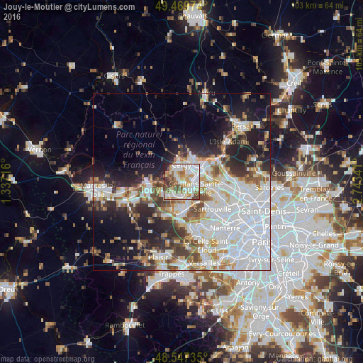
Analysis of Jouy-le-Moutier night lights 2016
Square area 10x10 km:
 24.26%
90-99
24.55%80-89
9.38%70-79
11.16%60-69
9.23%50-59
6.55%40-49
9.23%30-39
2.83%20-29
2.83%10-19
0%0-9
0%Square area 50x50 km:
17.28%90-99
9.63%80-89
3.67%70-79
3.86%60-69
4.11%50-59
3.84%40-49
4.79%30-39
3.93%20-29
7.84%10-19
12.37%0-9
28.69%Clear (daylight) street map image can be seen on geolist.org.
Map coordinates:
49° 28' 11.1" North, 1° 20' 13.8" East
49° 0' 38.4" North, 2° 2' 25" East
48° 32' 50.5" North, 2° 44' 36.3" East
Some cities around Jouy-le-Moutier sort by population:
• Cergy-Pontoise
4.2 km =2.6 mi,  41°
41°
• Cergy
3.9 km =2.4 mi, 42°
• Conflans-Sainte-Honorine
4.3 km =2.7 mi,  103°
103°
• Vauréal
2.6 km =1.6 mi,  348°
348°
• Andrésy
3.4 km =2.1 mi,  158°
158°
• Triel-sur-Seine
4.3 km =2.7 mi,  213°
213°
• Chanteloup-les-Vignes
3.9 km =2.4 mi,  188°
188°
• Courdimanche
4 km =2.5 mi,  313°
313°
3012162 (p: 19,087)
Sources (retrieved 2019-11-25):
» Earth at Night: Flat Maps 2012, 2016