Verneuil-sur-Seine night lights from space
Night Light of Verneuil-sur-Seine (Île-de-France) from space (France) Src. Average luminocity for 10x10km area is 64.1335% and for 50x50km: 43.149%.
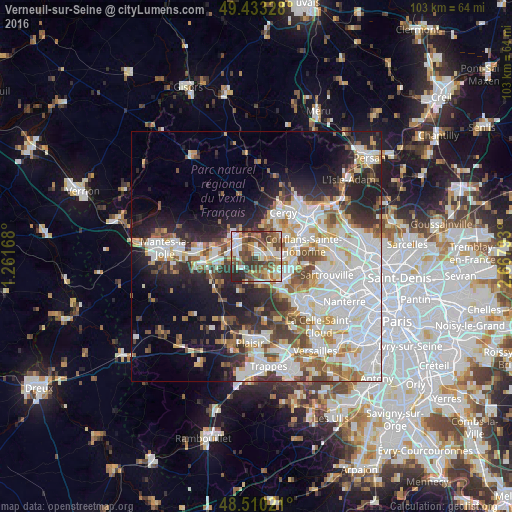
Analysis of Verneuil-sur-Seine night lights 2016
Square area 10x10 km:
 11.08%
90-99
13.07%80-89
9.52%70-79
6.68%60-69
9.8%50-59
12.93%40-49
18.47%30-39
10.94%20-29
7.39%10-19
0.14%0-9
0%Square area 50x50 km:
13.91%90-99
10.41%80-89
3.79%70-79
3.9%60-69
4.42%50-59
4.12%40-49
4.92%30-39
4.31%20-29
7.76%10-19
10.75%0-9
31.72%Clear (daylight) street map image can be seen on geolist.org.
Map coordinates:
49° 25' 59.8" North, 1° 15' 42" East
48° 58' 26" North, 1° 57' 53.3" East
48° 30' 36.8" North, 2° 40' 4.5" East
Some cities around Verneuil-sur-Seine sort by population:
• Les Mureaux
4.5 km =2.8 mi,  296°
296°
• Triel-sur-Seine
3.1 km =1.9 mi,  81°
81°
• Vernouillet
1.2 km =0.7 mi,  102°
102°
• Chanteloup-les-Vignes
5 km =3.1 mi,  87°
87°
• Meulan-en-Yvelines
5.7 km =3.5 mi,  311°
311°
• Menucourt
6.2 km =3.9 mi,  10°
10°
• Orgeval
5.9 km =3.7 mi,  170°
170°
• Villennes-sur-Seine
4.1 km =2.5 mi,  151°
151°
2969796 (p: 16,790)
Sources (retrieved 2019-11-25):
» Earth at Night: Flat Maps 2012, 2016