Meulan-en-Yvelines night lights from space
Night Light of Meulan-en-Yvelines (Île-de-France) from space (France) Src. Average luminocity for 10x10km area is 51.1488% and for 50x50km: 34.9268%.
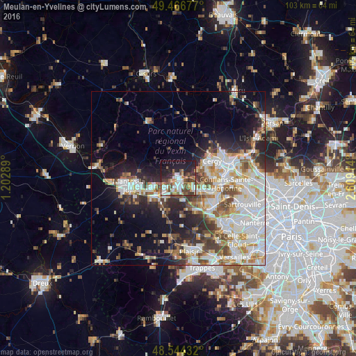
Analysis of Meulan-en-Yvelines night lights 2016
Square area 10x10 km:
 11.46%
90-99
10.42%80-89
2.83%70-79
7.74%60-69
5.21%50-59
7.59%40-49
11.9%30-39
5.51%20-29
16.67%10-19
17.26%0-9
3.42%Square area 50x50 km:
9.1%90-99
8.46%80-89
3.5%70-79
3.6%60-69
3.77%50-59
3.6%40-49
4.75%30-39
3.6%20-29
7%10-19
10.58%0-9
42.03%Clear (daylight) street map image can be seen on geolist.org.
Map coordinates:
49° 28' 0.4" North, 1° 12' 10.4" East
49° 0' 27.6" North, 1° 54' 21.7" East
48° 32' 39.6" North, 2° 36' 32.9" East
Some cities around Meulan-en-Yvelines sort by population:
• Les Mureaux
1.8 km =1.1 mi,  171°
171°
• Verneuil-sur-Seine
5.7 km =3.5 mi,  131°
131°
• Triel-sur-Seine
8.1 km =5 mi,  113°
113°
• Aubergenville
6.5 km =4 mi,  215°
215°
• Vernouillet
6.8 km =4.2 mi, 126°
• Gargenville
7.2 km =4.5 mi,  252°
252°
• Courdimanche
7.6 km =4.7 mi,  66°
66°
• Menucourt
5.9 km =3.7 mi, 66°
2994139 (p: 8,829)
Sources (retrieved 2019-11-25):
» Earth at Night: Flat Maps 2012, 2016