Vernouillet night lights from space
Night Light of Vernouillet (Île-de-France) from space (France) Src. Average luminocity for 10x10km area is 67.5099% and for 50x50km: 44.9638%.
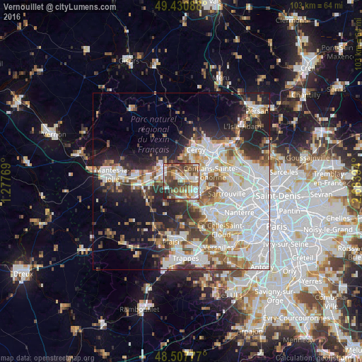
Analysis of Vernouillet night lights 2016
Square area 10x10 km:
 13.21%
90-99
15.06%80-89
9.23%70-79
6.96%60-69
11.79%50-59
12.78%40-49
17.19%30-39
9.8%20-29
3.84%10-19
0.14%0-9
0%Square area 50x50 km:
15.19%90-99
10.69%80-89
3.77%70-79
3.96%60-69
4.55%50-59
4.21%40-49
5.06%30-39
4.42%20-29
7.91%10-19
10.79%0-9
29.45%Clear (daylight) street map image can be seen on geolist.org.
Map coordinates:
49° 25' 51.2" North, 1° 16' 39.7" East
48° 58' 17.3" North, 1° 58' 51" East
48° 30' 28" North, 2° 41' 2.2" East
Some cities around Vernouillet sort by population:
• Les Mureaux
5.7 km =3.5 mi,  293°
293°
• Verneuil-sur-Seine
1.2 km =0.7 mi,  282°
282°
• Carrières-sous-Poissy
5 km =3.1 mi,  119°
119°
• Andrésy
5.7 km =3.5 mi,  77°
77°
• Triel-sur-Seine
2.1 km =1.3 mi,  68°
68°
• Chanteloup-les-Vignes
3.8 km =2.4 mi, 82°
• Orgeval
5.5 km =3.4 mi,  182°
182°
• Villennes-sur-Seine
3.4 km =2.1 mi,  167°
167°
2969751 (p: 9,965)
Sources (retrieved 2019-11-25):
» Earth at Night: Flat Maps 2012, 2016