Courdimanche night lights from space
Night Light of Courdimanche (Île-de-France) from space (France) Src. Average luminocity for 10x10km area is 53.9747% and for 50x50km: 39.4554%.
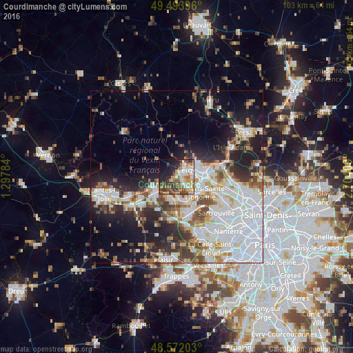
Analysis of Courdimanche night lights 2016
Square area 10x10 km:
 8.63%
8.63%90-99
11.76%80-89
6.1%70-79
9.23%60-69
9.52%50-59
6.25%40-49
10.57%30-39
6.85%20-29
13.69%10-19
12.2%0-9
5.21%Square area 50x50 km:
13.61%90-99
8.58%80-89
3.11%70-79
3.53%60-69
3.77%50-59
3.58%40-49
4.7%30-39
3.77%20-29
7.88%10-19
11.51%0-9
35.98%Clear (daylight) street map image can be seen on geolist.org.
Map coordinates:
49° 29' 38.3" North, 1° 17' 52.2" East
49° 2' 6.5" North, 2° 0' 3.5" East
48° 34' 19.3" North, 2° 42' 14.7" East
Some cities around Courdimanche sort by population:
• Cergy-Pontoise
5.6 km =3.5 mi,  85°
85°
• Cergy
5.5 km =3.4 mi, 88°
• Vauréal
2.4 km =1.5 mi, 94°
• Jouy-le-Moutier
4 km =2.5 mi,  133°
133°
• Osny
6 km =3.7 mi,  49°
49°
• Triel-sur-Seine
6.3 km =3.9 mi,  175°
175°
• Chanteloup-les-Vignes
7 km =4.3 mi,  160°
160°
• Menucourt
1.7 km =1.1 mi,  243°
243°
3023044 (p: 6,256)
Sources (retrieved 2019-11-25):
» Earth at Night: Flat Maps 2012, 2016