Triel-sur-Seine night lights from space
Night Light of Triel-sur-Seine (Île-de-France) from space (France) Src. Average luminocity for 10x10km area is 70.8381% and for 50x50km: 46.6567%.
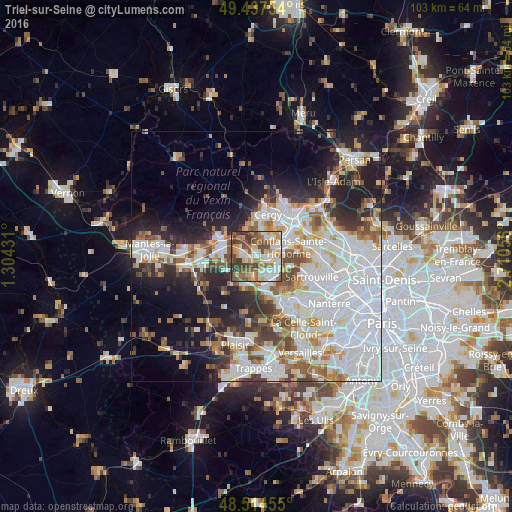
Analysis of Triel-sur-Seine night lights 2016
Square area 10x10 km:
 12.64%
90-99
18.04%80-89
11.79%70-79
9.23%60-69
12.07%50-59
10.65%40-49
14.49%30-39
10.09%20-29
0.99%10-19
0%0-9
0%Square area 50x50 km:
16.84%90-99
10.86%80-89
3.77%70-79
3.97%60-69
4.62%50-59
4.22%40-49
4.93%30-39
4.13%20-29
7.8%10-19
11.21%0-9
27.66%Clear (daylight) street map image can be seen on geolist.org.
Map coordinates:
49° 26' 15.1" North, 1° 18' 15.5" East
48° 58' 41.4" North, 2° 0' 26.7" East
48° 30' 52.4" North, 2° 42' 38" East
Some cities around Triel-sur-Seine sort by population:
• Achères
4.9 km =3 mi,  112°
112°
• Jouy-le-Moutier
4.3 km =2.7 mi,  33°
33°
• Verneuil-sur-Seine
3.1 km =1.9 mi,  261°
261°
• Carrières-sous-Poissy
4 km =2.5 mi,  142°
142°
• Andrésy
3.6 km =2.2 mi,  82°
82°
• Vernouillet
2.1 km =1.3 mi,  248°
248°
• Chanteloup-les-Vignes
1.9 km =1.2 mi,  97°
97°
• Villennes-sur-Seine
4.3 km =2.7 mi,  195°
195°
2971689 (p: 12,574)
Sources (retrieved 2019-11-25):
» Earth at Night: Flat Maps 2012, 2016