Graulhet night lights from space
Night Light of Graulhet (Occitanie) from space (France) Src. Average luminocity for 10x10km area is 7.7167% and for 50x50km: 6.4891%.
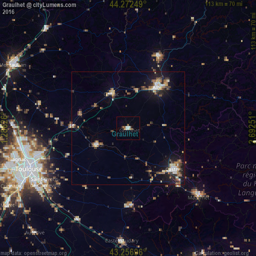
Analysis of Graulhet night lights 2016
Square area 10x10 km:
 0.91%
0.91%90-99
2.12%80-89
0.61%70-79
0.61%60-69
0.61%50-59
1.36%40-49
0.91%30-39
0.76%20-29
1.21%10-19
0%0-9
90.91%Square area 50x50 km:
0.62%90-99
0.9%80-89
0.75%70-79
0.84%60-69
0.81%50-59
1.1%40-49
0.78%30-39
0.98%20-29
1.59%10-19
4.58%0-9
87.04%Clear (daylight) street map image can be seen on geolist.org.
Map coordinates:
44° 16' 21" North, 1° 17' 10.5" East
43° 46' 0.8" North, 1° 59' 21.8" East
43° 15' 25.1" North, 2° 41' 33" East
Some cities around Graulhet sort by population:
• Albi
22.1 km =13.7 mi,  35°
35°
• Castres
26.9 km =16.7 mi,  131°
131°
• Gaillac
16.7 km =10.4 mi,  333°
333°
• Carmaux
34.4 km =21.4 mi,  23°
23°
• Lavaur
15.7 km =9.8 mi,  241°
241°
• Saint-Juéry
27.3 km =17 mi, 41°
• Saint-Sulpice-la-Pointe
24.4 km =15.2 mi,  272°
272°
• Labruguière
33.6 km =20.9 mi,  138°
138°
3014828 (p: 13,057)
Sources (retrieved 2019-11-25):
» Earth at Night: Flat Maps 2012, 2016