Lavaur night lights from space
Night Light of Lavaur (Occitanie) from space (France) Src. Average luminocity for 10x10km area is 8.8636% and for 50x50km: 7.0663%.
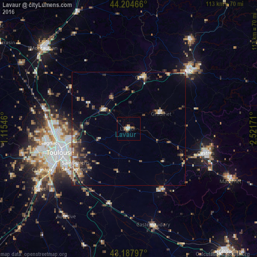
Analysis of Lavaur night lights 2016
Square area 10x10 km:
 0.91%
0.91%90-99
1.52%80-89
0.61%70-79
0.76%60-69
1.67%50-59
1.97%40-49
1.67%30-39
0.3%20-29
1.82%10-19
0%0-9
88.79%Square area 50x50 km:
0.43%90-99
0.91%80-89
0.92%70-79
0.89%60-69
0.97%50-59
1.28%40-49
1.41%30-39
1.22%20-29
2.12%10-19
2.85%0-9
86.98%Clear (daylight) street map image can be seen on geolist.org.
Map coordinates:
44° 12' 16.8" North, 1° 6' 55.7" East
43° 41' 54.5" North, 1° 49' 6.9" East
43° 11' 16.7" North, 2° 31' 18.2" East
Some cities around Lavaur sort by population:
• Balma
27.4 km =17 mi,  249°
249°
• Graulhet
15.7 km =9.8 mi,  61°
61°
• Gaillac
23.4 km =14.5 mi,  15°
15°
• Saint-Orens-de-Gameville
28 km =17.4 mi,  234°
234°
• L'Union
27.3 km =17 mi,  261°
261°
• Saint-Jean
25.9 km =16.1 mi, 261°
• Saint-Sulpice-la-Pointe
13.7 km =8.5 mi,  308°
308°
• Escalquens
29 km =18 mi, 226°
3005735 (p: 10,148)
Sources (retrieved 2019-11-25):
» Earth at Night: Flat Maps 2012, 2016