Saint-Juéry night lights from space
Night Light of Saint-Juéry (Occitanie) from space (France) Src. Average luminocity for 10x10km area is 23.0778% and for 50x50km: 3.8666%.
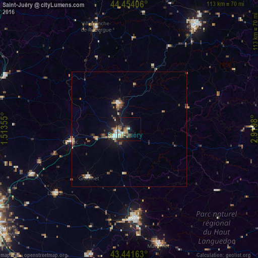
Analysis of Saint-Juéry night lights 2016
Square area 10x10 km:
 2.38%
2.38%90-99
3.65%80-89
3.65%70-79
2.86%60-69
2.22%50-59
4.13%40-49
2.7%30-39
5.56%20-29
5.24%10-19
18.41%0-9
49.21%Square area 50x50 km:
0.28%90-99
0.54%80-89
0.45%70-79
0.42%60-69
0.5%50-59
0.69%40-49
0.65%30-39
0.74%20-29
0.75%10-19
2.78%0-9
92.2%Clear (daylight) street map image can be seen on geolist.org.
Map coordinates:
44° 27' 14.6" North, 1° 30' 48.8" East
43° 57' 0" North, 2° 13' 0" East
43° 26' 29.9" North, 2° 55' 11.3" East
Some cities around Saint-Juéry sort by population:
• Albi
5.9 km =3.7 mi,  247°
247°
• Castres
38.3 km =23.8 mi,  177°
177°
• Villefranche-de-Rouergue
46.9 km =29.1 mi,  342°
342°
• Graulhet
27.3 km =17 mi,  221°
221°
• Gaillac
26.2 km =16.3 mi,  258°
258°
• Carmaux
12.2 km =7.6 mi, 337°
• Lavaur
42.4 km =26.3 mi,  228°
228°
• Labruguière
45.9 km =28.5 mi, 175°
2979148 (p: 6,997)
Sources (retrieved 2019-11-25):
» Earth at Night: Flat Maps 2012, 2016