Labruguière night lights from space
Night Light of Labruguière (Occitanie) from space (France) Src. Average luminocity for 10x10km area is 15.5476% and for 50x50km: 4.6539%.
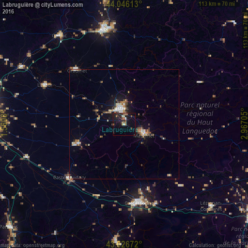
Analysis of Labruguière night lights 2016
Square area 10x10 km:
 0.16%
0.16%90-99
1.75%80-89
1.27%70-79
0.79%60-69
2.38%50-59
4.44%40-49
1.27%30-39
0.48%20-29
7.46%10-19
21.11%0-9
58.89%Square area 50x50 km:
0.34%90-99
0.65%80-89
0.5%70-79
0.64%60-69
0.62%50-59
0.65%40-49
0.69%30-39
0.69%20-29
1.2%10-19
3.01%0-9
91.02%Clear (daylight) street map image can be seen on geolist.org.
Map coordinates:
44° 2' 46.1" North, 1° 33' 38.9" East
43° 32' 18.9" North, 2° 15' 50.1" East
43° 1' 36.2" North, 2° 58' 1.4" East
Some cities around Labruguière sort by population:
• Carcassonne
36.8 km =22.9 mi,  168°
168°
• Castres
7.7 km =4.8 mi,  345°
345°
• Graulhet
33.6 km =20.9 mi,  318°
318°
• Castelnaudary
35 km =21.7 mi,  225°
225°
• Mazamet
10.3 km =6.4 mi,  121°
121°
• Revel
22.7 km =14.1 mi,  246°
246°
• Aussillon
9.3 km =5.8 mi, 115°
• Trèbes
39.2 km =24.4 mi,  158°
158°
3010720 (p: 5,846)
Sources (retrieved 2019-11-25):
» Earth at Night: Flat Maps 2012, 2016