Carmaux night lights from space
Night Light of Carmaux (Occitanie) from space (France) Src. Average luminocity for 10x10km area is 16.127% and for 50x50km: 3.8444%.
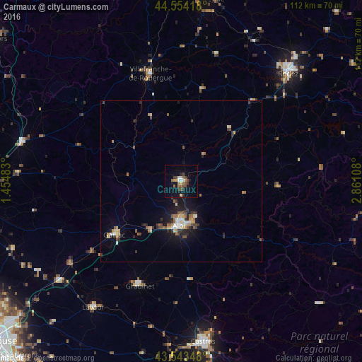
Analysis of Carmaux night lights 2016
Square area 10x10 km:
 0.63%
0.63%90-99
2.54%80-89
1.27%70-79
1.27%60-69
2.86%50-59
2.38%40-49
4.92%30-39
2.22%20-29
1.9%10-19
9.84%0-9
70.16%Square area 50x50 km:
0.29%90-99
0.45%80-89
0.53%70-79
0.44%60-69
0.52%50-59
0.62%40-49
0.61%30-39
0.75%20-29
0.8%10-19
2.78%0-9
92.21%Clear (daylight) street map image can be seen on geolist.org.
Map coordinates:
44° 33' 15" North, 1° 27' 17.4" East
44° 3' 3.6" North, 2° 9' 28.6" East
43° 32' 36.5" North, 2° 51' 39.9" East
Some cities around Carmaux sort by population:
• Albi
13.5 km =8.4 mi,  183°
183°
• Rodez
47.1 km =29.3 mi,  44°
44°
• Villefranche-de-Rouergue
34.8 km =21.6 mi,  343°
343°
• Graulhet
34.4 km =21.4 mi,  203°
203°
• Gaillac
26.7 km =16.6 mi,  231°
231°
• Lavaur
47.7 km =29.6 mi,  214°
214°
• Saint-Juéry
12.2 km =7.6 mi,  157°
157°
• Luc-la-Primaube
42 km =26.1 mi,  45°
45°
3028580 (p: 10,413)
Sources (retrieved 2019-11-25):
» Earth at Night: Flat Maps 2012, 2016