Saint-Sulpice-la-Pointe night lights from space
Night Light of Saint-Sulpice-la-Pointe (Occitanie) from space (France) Src. Average luminocity for 10x10km area is 10.953% and for 50x50km: 14.0238%.
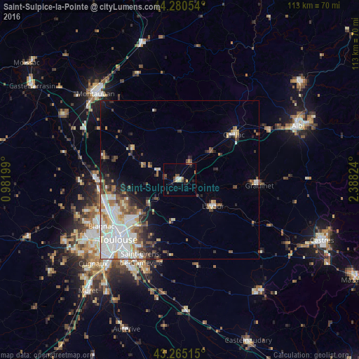
Analysis of Saint-Sulpice-la-Pointe night lights 2016
Square area 10x10 km:
 0.61%
0.61%90-99
0.61%80-89
2.12%70-79
1.21%60-69
0.91%50-59
2.12%40-49
2.42%30-39
1.52%20-29
2.12%10-19
1.52%0-9
84.85%Square area 50x50 km:
3.66%90-99
3.44%80-89
1.44%70-79
1.12%60-69
1.32%50-59
1.62%40-49
1.7%30-39
1.44%20-29
2.24%10-19
3.1%0-9
78.92%Clear (daylight) street map image can be seen on geolist.org.
Map coordinates:
44° 16' 49.9" North, 0° 58' 55.2" East
43° 46' 30" North, 1° 41' 6.4" East
43° 15' 54.5" North, 2° 23' 17.7" East
Some cities around Saint-Sulpice-la-Pointe sort by population:
• Balma
23.6 km =14.7 mi,  219°
219°
• Gaillac
22.1 km =13.7 mi,  50°
50°
• L'Union
20.7 km =12.9 mi,  231°
231°
• Lavaur
13.7 km =8.5 mi,  128°
128°
• Castelginest
22.1 km =13.7 mi,  245°
245°
• Aucamville
23.7 km =14.7 mi,  240°
240°
• Launaguet
21.3 km =13.2 mi, 239°
• Villemur-sur-Tarn
17.9 km =11.1 mi,  304°
304°
2976879 (p: 6,714)
Sources (retrieved 2019-11-25):
» Earth at Night: Flat Maps 2012, 2016