Domont night lights from space
Night Light of Domont (Île-de-France) from space (France) Src. Average luminocity for 10x10km area is 62.317% and for 50x50km: 58.4638%.
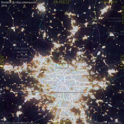
Analysis of Domont night lights 2016
Square area 10x10 km:
 19.05%
90-99
12.35%80-89
4.91%70-79
5.65%60-69
9.67%50-59
9.82%40-49
6.25%30-39
9.82%20-29
17.26%10-19
5.21%0-9
0%Square area 50x50 km:
26.12%90-99
13.16%80-89
4.46%70-79
3.93%60-69
4.35%50-59
4.19%40-49
4.68%30-39
4.3%20-29
7.09%10-19
13.17%0-9
14.55%Clear (daylight) street map image can be seen on geolist.org.
Map coordinates:
49° 29' 12.2" North, 1° 37' 23.7" East
49° 1' 40.2" North, 2° 19' 35" East
48° 33' 52.7" North, 3° 1' 46.2" East
Some cities around Domont sort by population:
• Eaubonne
4.7 km =2.9 mi,  223°
223°
• Montmorency
4.6 km =2.9 mi,  164°
164°
• Soisy-sous-Montmorency
4.8 km =3 mi,  202°
202°
• Saint-Brice-sous-Forêt
3.6 km =2.2 mi,  146°
146°
• Ézanville
3 km =1.9 mi,  89°
89°
• Écouen
4.2 km =2.6 mi,  100°
100°
• Saint-Prix
4.5 km =2.8 mi,  254°
254°
• Bouffémont
2.7 km =1.7 mi,  310°
310°
3021150 (p: 16,684)
Sources (retrieved 2019-11-25):
» Earth at Night: Flat Maps 2012, 2016