Écouen night lights from space
Night Light of Écouen (Île-de-France) from space (France) Src. Average luminocity for 10x10km area is 66.1533% and for 50x50km: 59.1029%.
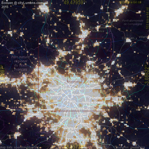
Analysis of Écouen night lights 2016
Square area 10x10 km:
 20.09%
90-99
17.86%80-89
4.91%70-79
4.32%60-69
7.89%50-59
9.82%40-49
7.74%30-39
10.12%20-29
12.65%10-19
4.61%0-9
0%Square area 50x50 km:
26.99%90-99
13.36%80-89
4.29%70-79
3.95%60-69
4.37%50-59
3.99%40-49
4.02%30-39
4.27%20-29
7.04%10-19
14.16%0-9
13.54%Clear (daylight) street map image can be seen on geolist.org.
Map coordinates:
49° 28' 46.5" North, 1° 40' 47.9" East
49° 1' 14.2" North, 2° 22' 59.1" East
48° 33' 26.6" North, 3° 5' 10.4" East
Some cities around Écouen sort by population:
• Sarcelles
2.6 km =1.6 mi,  187°
187°
• Villiers-le-Bel
1.7 km =1.1 mi,  140°
140°
• Montmorency
4.6 km =2.9 mi,  218°
218°
• Domont
4.2 km =2.6 mi,  280°
280°
• Saint-Brice-sous-Forêt
3 km =1.9 mi,  225°
225°
• Arnouville
4.8 km =3 mi,  149°
149°
• Ézanville
1.4 km =0.9 mi,  306°
306°
• Groslay
4.7 km =2.9 mi,  213°
213°
3020440 (p: 7,583)
Sources (retrieved 2019-11-25):
» Earth at Night: Flat Maps 2012, 2016