Saint-Brice-sous-Forêt night lights from space
Night Light of Saint-Brice-sous-Forêt (Île-de-France) from space (France) Src. Average luminocity for 10x10km area is 80.7128% and for 50x50km: 62.4474%.
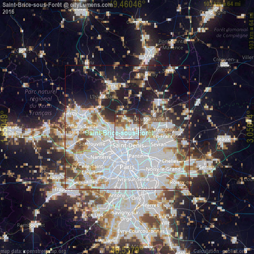
Analysis of Saint-Brice-sous-Forêt night lights 2016
Square area 10x10 km:
 35.12%
90-99
22.47%80-89
5.21%70-79
4.32%60-69
8.04%50-59
9.97%40-49
4.46%30-39
6.99%20-29
3.42%10-19
0%0-9
0%Square area 50x50 km:
28.95%90-99
14.28%80-89
4.72%70-79
4.02%60-69
4.66%50-59
4.17%40-49
4.51%30-39
4.35%20-29
6.61%10-19
12.32%0-9
11.41%Clear (daylight) street map image can be seen on geolist.org.
Map coordinates:
49° 27' 37.7" North, 1° 39' 1.8" East
49° 0' 4.8" North, 2° 21' 13" East
48° 32' 16.4" North, 3° 3' 24.3" East
Some cities around Saint-Brice-sous-Forêt sort by population:
• Sarcelles
1.8 km =1.1 mi,  103°
103°
• Villiers-le-Bel
3.4 km =2.1 mi,  75°
75°
• Deuil-la-Barre
3.3 km =2.1 mi,  215°
215°
• Montmorency
1.6 km =1 mi,  207°
207°
• Montmagny
3.1 km =1.9 mi,  188°
188°
• Ézanville
3.1 km =1.9 mi,  19°
19°
• Groslay
1.8 km =1.1 mi, 194°
• Écouen
3 km =1.9 mi,  45°
45°
2981283 (p: 13,606)
Sources (retrieved 2019-11-25):
» Earth at Night: Flat Maps 2012, 2016