Saint-Prix night lights from space
Night Light of Saint-Prix (Île-de-France) from space (France) Src. Average luminocity for 10x10km area is 73.4985% and for 50x50km: 59.4253%.
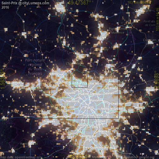
Analysis of Saint-Prix night lights 2016
Square area 10x10 km:
 29.91%
90-99
17.41%80-89
6.25%70-79
6.25%60-69
6.85%50-59
5.95%40-49
4.61%30-39
12.8%20-29
9.82%10-19
0.15%0-9
0%Square area 50x50 km:
27.01%90-99
13.15%80-89
4.56%70-79
4.04%60-69
4.37%50-59
4.05%40-49
4.78%30-39
4.39%20-29
7.45%10-19
12.81%0-9
13.39%Clear (daylight) street map image can be seen on geolist.org.
Map coordinates:
49° 28' 32.4" North, 1° 33' 48.8" East
49° 1' 0" North, 2° 16' 0" East
48° 33' 12.2" North, 2° 58' 11.3" East
Some cities around Saint-Prix sort by population:
• Franconville
4.4 km =2.7 mi,  213°
213°
• Ermont
3 km =1.9 mi,  192°
192°
• Taverny
3.8 km =2.4 mi,  285°
285°
• Eaubonne
2.5 km =1.6 mi,  152°
152°
• Soisy-sous-Montmorency
4.1 km =2.5 mi,  141°
141°
• Domont
4.5 km =2.8 mi,  74°
74°
• Le Plessis-Bouchard
3.1 km =1.9 mi,  232°
232°
• Bouffémont
3.8 km =2.4 mi,  37°
37°
2977317 (p: 7,226)
Sources (retrieved 2019-11-25):
» Earth at Night: Flat Maps 2012, 2016