Bouffémont night lights from space
Night Light of Bouffémont (Île-de-France) from space (France) Src. Average luminocity for 10x10km area is 48.7976% and for 50x50km: 55.7465%.
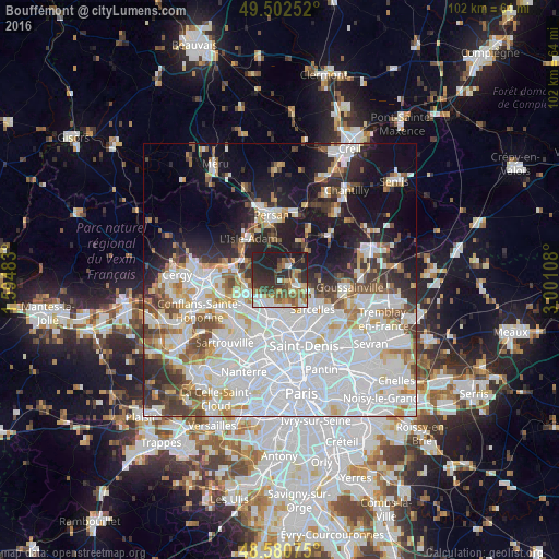
Analysis of Bouffémont night lights 2016
Square area 10x10 km:
 7.29%
7.29%90-99
7.59%80-89
3.72%70-79
5.06%60-69
10.71%50-59
10.42%40-49
5.8%30-39
12.8%20-29
22.17%10-19
14.43%0-9
0%Square area 50x50 km:
24.37%90-99
12.51%80-89
4.26%70-79
3.7%60-69
4.15%50-59
4.05%40-49
4.61%30-39
4.36%20-29
7.48%10-19
13.51%0-9
16.98%Clear (daylight) street map image can be seen on geolist.org.
Map coordinates:
49° 30' 9.1" North, 1° 35' 41.4" East
49° 2' 37.6" North, 2° 17' 52.7" East
48° 34' 50.7" North, 3° 0' 3.9" East
Some cities around Bouffémont sort by population:
• Taverny
6.3 km =3.9 mi,  250°
250°
• Eaubonne
5.3 km =3.3 mi,  192°
192°
• Soisy-sous-Montmorency
6.2 km =3.9 mi,  177°
177°
• Domont
2.7 km =1.7 mi,  130°
130°
• Saint-Leu-la-Forêt
4.6 km =2.9 mi,  229°
229°
• Saint-Brice-sous-Forêt
6.2 km =3.9 mi,  139°
139°
• Ézanville
5.4 km =3.4 mi,  109°
109°
• Saint-Prix
3.8 km =2.4 mi,  217°
217°
3031294 (p: 5,652)
Sources (retrieved 2019-11-25):
» Earth at Night: Flat Maps 2012, 2016